|
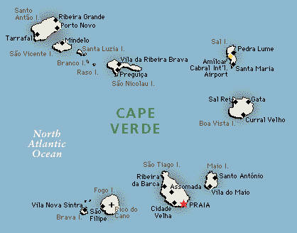
Archipelago of Cape Verde
The Republic of Cape Verde is situated in the Atlantic Ocean (Macaronesia Eco region) and is 450kms from the Western African Coast. It is an archipelago composed of ten islands (of which nine are inhabited) and eight islets, covering 4,000 square kilometers. Of volcanic origin, the islands are divided into two areas: the Barlavento (windward) islands (Santo Antão, São Vicente, Santa Luzia, São Nicolau, Sal, and Boavista) and the Sotavento (leeward) islands (Maio, Santiago, Fogo, and Brava).
These islands are divided into 22 municipalities and subdivided into 32 parishes. The largest island, both in size and population, is Santiago, where the capital of Praia is located.
Benefiting from a tropical dry climate with moderate water and air temperatures, Cape Verdeans are, by nature, happy and hospitable.
Island of Santiago
This is the largest island of the archipelago, with 991 km2. Its main city, Praia, is the capital of Cape Verde, with a population of approximately 90.000 inhabitants. Praia is located in the southern area of Santiago. It is the starting point for the discovery of citys and villages full of charm such as the old town of "Cidade Velha", the former capital, or Tarrafal, that surprises us with its exotic nature and its cosy bay with the coconut tree lined beach.
Cruz do Papa (view over the Quebra Canela beach)
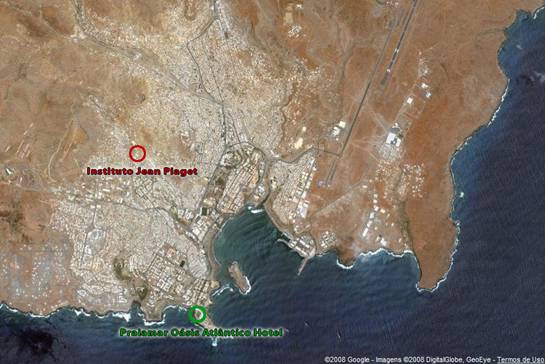
Location of the Jean Piaget Institute and the Praiamar Oásis Atlântico hotel:
Island of Boavista
This is the eastern most island, with approximately 640km2. Through a meeting of the Portuguese "Fado" and the African rhythms, on this island the "morna" was born, a melancholy and lyrical song form typically sung in Cape Verdean Creole.
Boavista has the most extensive beaches in Cape Verde and has recently been the target of investors in tourism that have constructed various hotels and turistic infrastructures. There are good conditions for free diving in the various inlets that surround this island.
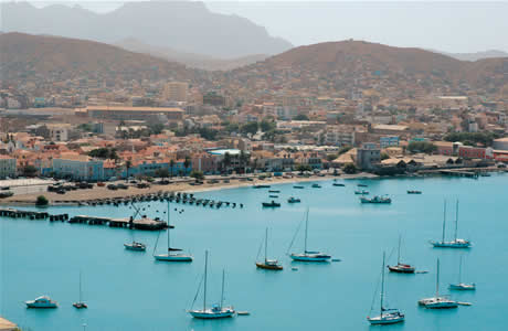
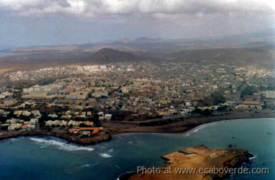
Island of São Vicente
The island of São Vicente has a surface of 227 km² and is the second most populated island in Cape Verde. Though it is of volcanic origin, the island is relatively flat, especially in the centre area, the eastern area of Calhau and the northern area of Baía das Gatas. The island has a dry and arid aspect and has its main source of income is from the area of tourism, fishing and the exploitation of its busy ocean port - o Porto Grande - .
What every visitor should know
Dry tropical with a rainy season from August to October.
| |
JAN |
FEB |
MAR |
APR |
MAY |
JUN |
JUL |
AUG |
SEP |
OCT |
NOV |
DEC |
AIR |
22º |
22º |
24º |
24º |
24º |
24º |
26º |
28º |
26º |
24º |
24º |
22º |
WATER |
20º |
20º |
20º |
22º |
22º |
24º |
24º |
24º |
24º |
24º |
22º |
22º |
Portuguese is the official language but Creole is the recognized regional language.
The local currency is the Cape Verdean escudo (CVE). The exchange of currency can be made in the banks from Monday to Friday 08h-15h or
in the hotels. Credit cards have restricted usage and ATM machines are very limited.
220 V euopean plugs
|